

|
~
|
 Development and use of compact instruments for tropospheric investigations based on optical spectroscopy from mobile platforms Thesis directors : Xavier Urbain, Alain Cornet (UCL) and Michel Van Roozendael (BIRA-IASB) : Abstract : This thesis presents the development of four different remote-sensing instruments dedicated to atmospheric research and their use in field campaigns between 2008 and 2012. The instruments are based on uv-visible spectrometers and installed respectively on a scientific aircraft (Safire ATR-42), ultralight aircraft, and cars. One of the instruments is targeted to operate from an UAV. The DOAS technique is used to quantify the molecular absorption in the spectra of scattered sky light. These absorptions are then interpreted by modeling the radiative transfer in the atmosphere. Depending on the instrument, different information on trace gases and aerosols are retrieved: vertical distributions, tropospheric columns, or maps of surface abundances. Airborne platforms enable new measurement geometries, leading for instance to a high sensitivity in the free troposphere. On the other hand, a miniaturization effort is required, especially for the instruments onboard ultralight aircraft and UAV. Reaching the limited size, weight, and power consumption is possible through the use of compact spectrometers and computers, together with custom built electronics circuits and housings. The inversion strategies are optimized for each instrument with proper error budgets and the results are compared with other datasets when available.
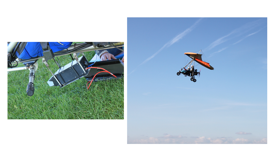
Installation of the SWING instrument on an ultralight and test flight (28 October 2012). In April 2008, the ALS-DOAS was first used on the ATR-42 to derive NO2 and aerosol extinction profiles during the POLar study using Aircraft, Remote sensing, surface measurements and models, of Climate chemistry, Aerosols and Transport (POLARCAT). It revealed in particular that NO2, despite its typical lifetime of a few hours, may be transported from mid-latitude Europe to the Arctic. This is not visible in satellite data since the involved concentrations are under the detection limit. The ULM-DOAS was operated during the Earth Challenge expedition in April, October, and December 2009. This expedition provided an opportunity to perform measurements from an ultralight between Australia and Belgium, crossing areas were few local measurements have been reported, such as Bangladesh, Rajasthan, Saudi Arabia, and Libya. The ULM-DOAS measurements of tropospheric NO2 columns mostly fall within the confidence interval of satellite data but indicate that the NO2 columns over Riyadh may be underestimated by the Ozone Monitoring Instrument (OMI). In addition, the ULM-DOAS data provided a confirmation for the recent finding of a soil signature in the spectra recorded above desert. The Mobile-DOAS, operated from a car, was developed and first operated during the Cabauw Intercomparison Campaign of Nitrogen Dioxide measuring Instruments (CINDI) in the Netherlands during June and July 2009. Routine measurements in 2010 and 2011, mostly across Belgium yielded a large database of measurements which was compared with a chemical transport model (CHIMERE). The geometric approximation was not used to evaluate the database, since air mass factors calculations indicate that the associated uncertainties are larger than expected from previous studies. Finally, the UAV payload, the SWING was tested from an ultralight aircraft in July and October 2012. One major objective of the UAV measurements is the mapping of NO2 columns at high spatial resolution allowing to subsample satellite measurements within the extent of a typical ground pixel. This has yet to be achieved. Download the PDF file (48 Mb) : ThesisMerlaudNet.pdf Download the PowerPoint presentation (in French) : PresentationPubliqueAlexis.pps
Contact For more information, please contact : Alexis Merlaud |

Last update on 26 Mar 2013