Alexis Merlaud successfully defended his PhD thesis
|
| |
|
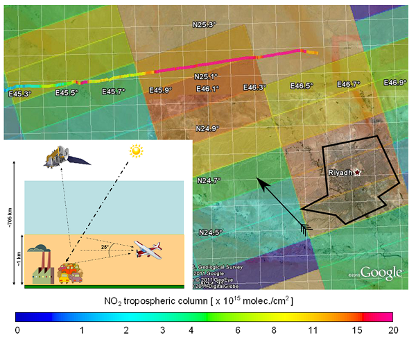
The map shows Riyadh surrounding, with ULM-DOAS and OMI NO2 data superimposed. Riyadh agglomeration is delimited by the black polygon. The arrow indicates the wind direction according to the GDAS archive.
|
On the 18th of March 2013, Alexis Merlaud successfully defended his doctoral thesis at UCL in Louvain-La-Neuve. The title of this doctoral thesis is: "Development and use of compact instruments for tropospheric investigations based on optical spectroscopy from mobile platforms". The Phd promotors were Xavier Urbain and Alain Cornet from UCL, and Michel Van Roozendael from BIRA-IASB.
This thesis presents the development of four different remote-sensing
instruments dedicated to atmospheric research and their use in field
campaigns between 2008 and 2012. The instruments are based on uv-visible
spectrometers and installed respectively on a scientific aircraft,
ultralight aircraft, and cars. One of the instruments is targeted to
operate from an Unmanned Aerial Vehicle (UAV). The Differential Optical
Absorption Spectroscopy (DOAS) technique is used to quantify the molecular
absorption in the spectra of scattered sky light. These absorptions are
then interpreted by modeling the transfer of radiation in the atmosphere.
Airborne platforms enable new measurement geometries, leading for instance
to a high sensitivity in the free troposphere. On the other hand, a
miniaturization effort is required, especially for the instruments onboard
ultralight aircraft and UAV. Reaching the limited size, weight, and power
consumption is possible through the use of compact spectrometers and
computers, together with custom built electronics circuits and housings.
A common target of the different experiments is to quantify tropospheric
nitrogen dioxide (NO2). Regarding this trace gas, the developed
instruments provide complementary findings, such as the vertical
distribution in the pristine Arctic or the levels in the exhaust plumes of
large cities like Riyadh. Car-borne measurements in North-West Europe
reveal the horizontal gradients of surface NO2 at various scales. The UAV
payload is intended to produce high spatial resolution maps of
tropospheric NO2 columns. More...